Thursday, July 28, 2011

Stream Beyond Walnut Mountain Road to Past Vandeventer Shelter---April 30th

An oak leaf lies upon the trail, its color rustic brown.
How long is it, oh little leaf, since you came drifting down?

Laurel Fork Falls is a royal cascade.
Granola bars for lunch in the shade.

The regular ups and downs this morning, but nothing too strenuous.  It was the section of trail between the side trail to Coon Den Falls and Pond Flats that was truly exceptional.  The mountainside was dotted with the pink of mountain laurel in full bloom.  The path climbed steeply higher from the bridge that crossed Upper Laurel Fork, then as it levelled off it ran through little sheer-sided canyons  before finally making a precipitous, stony descent to the base of Laurel Fork Falls, a fabulous whitewater cascade dropping thirty feet over rocky stairs.  So fantastic to see and hear the rushing water! 
A perfect time to reach this idyllic spot just past noon with the sun shining directly overhead.  About a dozen people were sitting around on the rocks enjoying nature's showcase.  I found my own comfy place to crash for a bit, digging into my pack for the contents of today's lunch.  Sitting there eating and watching the movement of the water over the falls was quite mesmerizing.  A young couple decided to frolic in the deeper waters of the pool near the bottom.  They were already well-soaked by the time they reached it, slipping several times on the slick, rounded stones on the river bottom, losing their balance and falling into the refreshing wetness. 
Eventually, I roused myself and broke away from the enchanting scene.  However, I didn't go too far before finding another deep pool, its enticingly cool waters beyond my powers to resist.  A wonderful swim/bath exactly what I needed at that moment.  Every little ache or muscle soreness seemed to flow away with the passing current. I was completely re-energized!  I'd just put my clothes back on when a large group of day hikers strolled by.  It is Saturday after all.
Followed the course of the river for a bit before a brutal climb took me out of the canyon and into Pond Flats, an interesting area of trees interspersed with small basins, dry now, but looking as if they'd form shallow ponds in early spring as the snow melts.  At least that's how it appeared this locale earned its name.  I didn't mind the toughness of the ascent, but it made the subsequent hike down to Hampton (2,000 foot elevation loss) a strength test for my legs, which felt like noodles. 
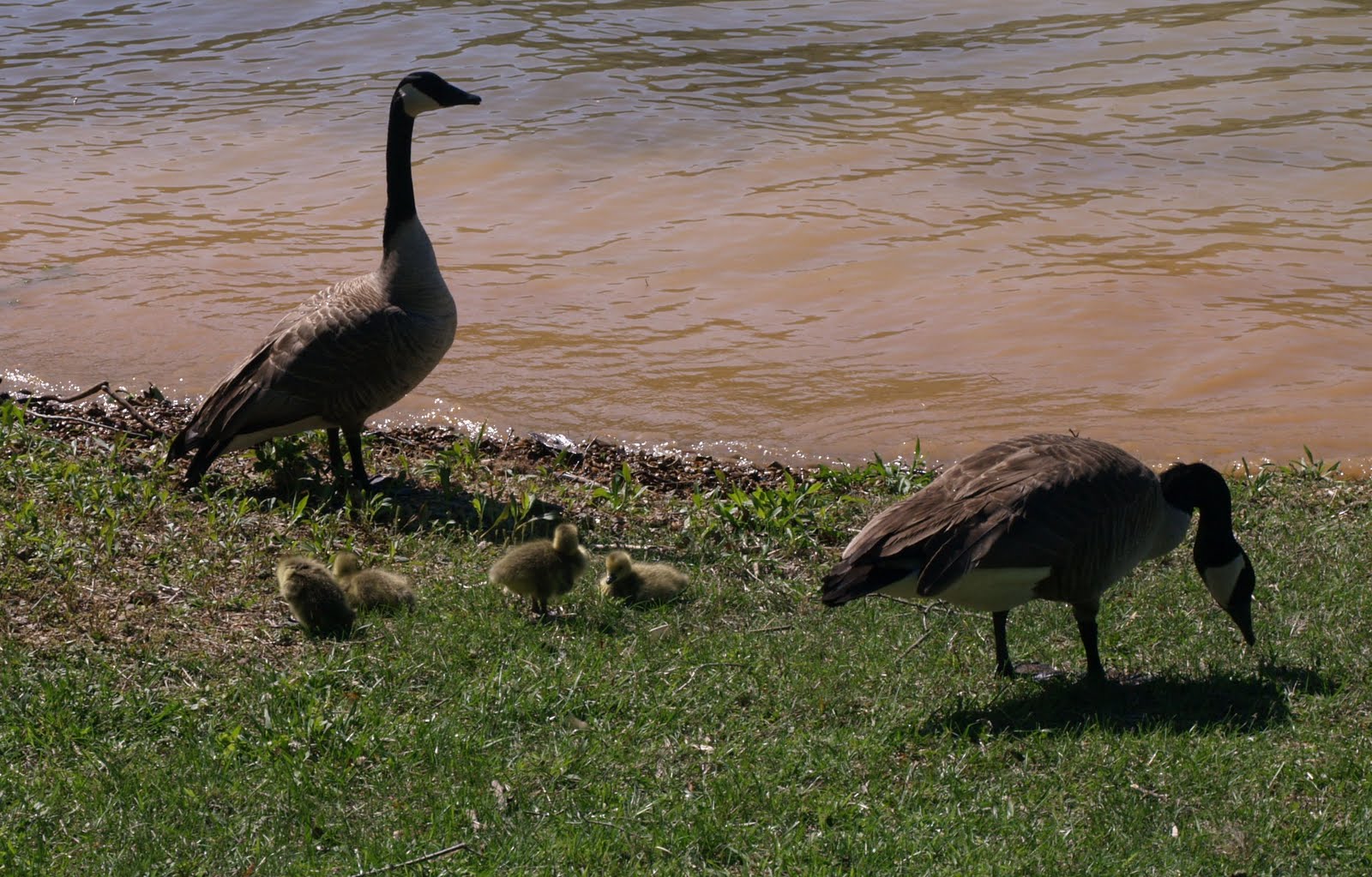
When I emerged from the woods on a country back road, I met an older gentleman, Bald Eagle, who was looking a bit perplexed, not knowing which way to turn.  To the right or to the left?  Getting my bearings, I soon set us both on the right path to the shores of Lake Watauga.  We shared a nice meal together at a picnic table in the regional park while gazing at Canadian Geese with their goslings and bikini-clad women, both an uncommon sight on a regular trail day.  Sorry, I don't mean to stare. HA!Bald Eagle was planning to stop for the night at Watauga Lake Shelter, but I had more ambitious designs. 
The trail skirted around the lake rising gradually from the shoreline before departing from it entirely.  An uphill push to the top of a ridge line placed me at Vandeventer Shelter about an hour before sunset.  It had been my planned stopping point, but it was readily apparent there was no room at the inn.  The shelter was packed to overflowing and what level ground there was, which wasn't much at all, already had tents set up.  I didn't even break stride as I walked past.  Darkness would soon envelop me and from what I'd seen on the way up, good campsites were something of a rarity.  Rushing on, I was looking for any suitable spot that presented itself.  About a mile further on I found a perfect little space off the trail at the edge of a small cliff.  As I set up my tent in the half-light, I saw lights winking on in a few country residences in the valley below.  Settled down in my tent feeling very happy and not quite so lonesome.

Moreland Gap Shelter
The Oldest Trail Shelter :-)
Bridge and Bluff
Upper Laurel Fork
Laurel Fork Falls
Flower and Fronds
Blossoms with Butterfly
Geese with Goslings


Past Vandeventer Shelter to Damascus---May 1st

Why when I am tired and have just shut my eyes
The daylight streams into the tent and tells me I must rise?

I think a mouse is following me, but each time I look back
I don't see or hear a thing except the squeeking of my pack.

Someone walked by my tent at six o'clock this morning, which is rather early to be out on the trail.  And I thought I was an early riser! Checking the register at Iron Mountain Shelter, I found out who it was.  Snorkel had signed in!  Turns out that she had spent the night at Vandeventer Shelter.  I had actually passed her yesterday evening without knowing it.  I'd started hiking before seven so she was less than an hour ahead and I was determined to close the remaining distance.  The first time I caught a glimpse of her, far in the distance, was after Tennessee 91 when she was climbing over a stile and entering the woods at the edge of a large grassy field.  I thought I'd catch her quickly, but after some time without running into anybody on the trail ahead of me, I began to doubt what I'd seen.  I mean I had kicked it into a pretty high gear and to see nobody on the woody trail ahead of me was discouraging.  As time continued to pass I rounded a small bend in the trail and there ahead of me was the person I'd been chasing for the past two weeks.
At first I really couldn't believe it, but I was so happy to achieve my goal.  Little did this stranger realize that she had provided a good deal of motivation for me at the beginning of this long trail and truth be told I was glad to meet somebody who was putting such an effort in everyday.  It was inspiring.  Snorkel must have been a little wary when I introduced myself and told her about my experience at Tray Gap in Georgia, where I'd initially heard about her and her attempt at the record.  I was fervently hoping that she would understand my reasons for trying to catch her and not think I was some crazy stalker. Ha.  Thankfully, she gave me the benefit of the doubt and we continued on our journey together.
We spent the remainder of the day talking about our time on trails.  Though we've both hiked thousands of miles, we certainly had different hiking experiences.  Snorkel had done the Appalachian Trail, the Continental Divide Trail and the Pacific Crest Trail, northbound.  I'd done the Pacific Crest Trail, southbound, and the Florida Trail.  From a hiking perspective, we certainly had a lot to talk about.  I appreciated her interest in my adventures and was very keen to learn about hers.
Being a Triple Crowner, Snorkel was one of a very few people I'd meet on the trail that had logged more miles than me.  I was really curious as to why she was going after the record. As she explained, it was simple really.  In her first thru-hike of the A.T.in 2008, it had taken her around 100 days to finish.  With subsequent thru-hikes on the Pacific Crest Trail and the Continental Divide Trail over the past couple of years she had gained a lot of experience and honed her abilities.  Looking for a challenge she had turned her attention back to the trail she'd started with.  Though no official records are kept, she was able to determine as far as she could that the women's unsupported record was (I believe) 86 days set by the wife of Ray Jardine.  Being a stronger and savvier hiker in 2011, Snorkel felt that setting a new record was reasonably achievable.
With the good conversation and another hiker to push the pace we breezed past the Tennessee/Virginia border and arrived in Damascus far earlier than either of us would have thought.  I was actually going to camp a bit short of the town, but Snorkel told me about "The Place" hostel run by the Methodist Church, so that's where we both wound up staying.  However, before we crashed at the hostel, we made a run to Food King to pick up some sustenance.  I'm a sucker for the little pies---blueberry, apple, lemon and cherry.  The remainder of the day was spent doing all the little things that hikers do when the opportunity presents itself---shower, shave, laundry, catching up on journal entries, eating a better meal than is typically had out in the woods, etc.  When I finally lay down to sleep on an upper bunk I realized it was the first bed I'd been in since my stay at the Hiker Hostel in Dahlonega, two weeks and three states ago.

Cliff Camp
Tennessee/Virginia Border
Red Flowers and Green Grass


Damascus to Thomas Knob Shelter---May 2nd

Left town late at 10:15 but busted nearly thirty.
In town I was clean-shaved and washed but now I'm smelly, dirty.

Pacific Crest, Appalachian Trail, wherever I may roam.
I'm comfy cozy, outlook rosy, in my tarptent home.

Sausages, Velveeta cheese, tortillas, snacks and more
The type of hiker food you find at the Dollar General store.

Morning comes early for a thru-hiker out on trail, but I got to sleep in a bit at the hostel.  Woke up late at 7.  Ha.  Had a couple of the fruit pies I bought at Food King for breakfast and then went on my resupply run to Dollar General, which opens at 8.  Sausages and a large block of Velveeta Cheese will make for a change of pace, replacing the peanut butter and jelly mix I've had for dinner up to this point.  Returned to "The Place" and packed up my stuff so I'm ready to go.  Library opens at 9 and I was hoping to use the Internet to send out a few I'm-still-OK messages to family and friends.  Sad to say that the Net was not working at all.  The librarian apologized for the inconvenience and contacted the trouble shooter, promising that it would be back up soon.  However, an hour later there was still no progress so I decided not to wait around any longer. 
Snorkel left 45 minutes before I did, her goal being the shelter on Thomas Knob.  Perhaps I could catch her before she reached it.  With this in mind, I strode out of town making good time on the path that forms both the Appalachian and Virginia Creeper Trails.  There were lots of springs and streams either crossing or running alongside the trail and the walking I felt was fairly easy.  The best part for me was when I was once again back near the high points of the trail.  There are some superb views from the Buzzard Rocks area and the high shoulder of Mt. Rogers.  I was quite happy to see the shelter in the later hours of evening because it appeared as if the weather was closing in, the dark grey sky making it seem as if it were closer to dusk than it actually was.  The tenting area before the shelter was packed and pulling up to the two-level wooden structure, I discovered it was just as crowded.  Everyone looked in fine spirits especially with the feral ponies providing some entertainment as they got it on right in front of the building. 
Didn't see Snorkel anywhere and frankly was surprised I didn't meet her on the trail.  I assumed she had set her hammock up back in the thicket of spruce.  Going a short distance further, I found a nice camp on level grassy ground that was off to the left of the trail, nicely secluded by a couple of large bushes.  Leaving late from Damascus, I was thrilled with the amount of ground I covered.  Lying inside my tent, I felt far removed from the blustery weather outside.  The evening meal of sausage, Velveeta cheese and tortillas was delicious.

Weather Closing In
Feral Ponies at Thomas Knob Shelter      


Thomas Knob Shelter to Partnership Shelter---May 3rd

The gorgeous Grayson Highlands, oh what a place to be,
Offering the best so far of A.T. scenery.

It didn't rain at night but a heavy dew put the wet on my tarptent.  Out on the trail around 6 a.m., I soon met Snorkel and we passed through the Grayson Highlands together in the fabulous morning light.  I wonder if early colonists found any similarities between this region of windswept grasses, rocky outcrops, stunted trees and bracken to the Scottish Highlands, the Midlands or Ben Nevis in Wales.  Walking in such a landscape reminded me of my mother's favorite book, Wuthering Heights.  We both enjoyed seeing a group of six or seven ponies trimming the grass along the trail as they browsed.  Extremely tiny for horses as the tallest would only come up to my waist, but well-built and insulated with a thick layer of hair to weather the harsh conditions up here even in the winter. 
At one point, upon reaching a trail marker, Snorkel and I came to the conclusion that we'd overshot a trail junction and were no longer on the A.T.  Felt a little red-faced to have such a thing happen to such experienced hikers, but it did.  Time to backtrack!  Twenty minutes later we discovered the reason for our error.  The Appalachian Trail cut sharply to the right between two overgrown rhododendron bushes that partially obscured the turning path.  In addition, the wooden trail sign was so weathered that even up close it was difficult to make out the words and recognize the direction arrow.  Later on the trail we met Craig from Germany.  He was waiting for his hiking partner Heinrich, who fit the description of a guy we passed as we were making our way back to the A.T.  It appeared that we weren't the only ones fooled that day.  We continued with Craig to Old Orchard Shelter where we took a break to fuel up on high calorie food and refill on water from the nearby creek.  Craig was going to park it there until his friend caught up.  I hoped that when Heinrich had reached the trail marker he had reversed his steps, like us, and got back to the true trail so Craig wouldn't have long to wait.
Most of the day was a big push for Partnership Shelter, a destination we'd both had in mind since we met this morning.  The weather slowly deteriorated until at six in the evening it started raining.  Nothing heavy but rather steady.  The last mile or so for me was tough going because the muscles were tired from the mileage and the body was sapped of strength by the cold and wet conditions.  Needless to say, the shelter was a most welcome sight.  Even with the earlier detour in the highlands, we'd covered 36 miles by 8:30.  Not bad at all. 
After settling down in the loft upstairs, Snorkel went out to order some pizza.  There's a phone hot line for that very purpose at the Mt. Rogers NRA Headquarters.  In the meantime, I changed into some dry clothes, realizing as I did so how hungry and cold I actually was.  When Snorkel returned with the food, we sat opposite each other in the small space at the foot of the ladder leading to the loft.  Words can't describe how incredibly good warm pizza and mini-cinnamon rolls are when you can see white puffs of exhaled breath as you're eating.  It certainly raises your appreciation for the simple things in life and how they can completely satisfy. 
Partnership shelter is unique for the fact that it actually has a hot shower.  However, on this chilly night I had to laugh at the words of one of the female hikers, Toaster, who was sharing the space upstairs.  She said that she had seriously thought about taking advantage of the opportunity to have a shower, but was put off by the thought that after emerging from the hot water, she'd have to dry off and get dressed in the cold with her feet on the frigid floor.  "In the end", she stated succinctly, "I felt it was just better to remain warm and smelly."  Now that's a motto for a thru-hiker!  To my knowledge, all at the shelter that night went to bed shower-less.

Day Dawns on the Grayson Highlands
'Tween the Rocks
A Chance Encounter with Snorkel
Feral Ponies
Shaggy and Stout


Partnership Shelter to Lick Creek---May 4th

The water isn't safe it says, I guess I'll have to boil it.
For God knows who or what upstream has gone and used the toilet.

The pitter patter of raindrops on the shelter roof had ceased by the time I awoke to a fairly clear yet cold morning.  Snorkel and I proceeded to Atkins, where she resupplied.  For lunch we went to The Barn Restaurant.  Can't rightly remember what I ordered, but do recall guzzling lots of soda refills as for some reason I felt very thirsty. 
Afterwards, I pushed on alone because Snorkel's plans and mine are a bit different over the next several days.  Perhaps we'll meet again.  Not something I'd consider with other hikers I've passed, but I knew Snorkel could put in the miles.  In the meantime, I was headed to Pearisburg and she was taking a couple of zeros once she reached Woodshole Hostel.  I was thankful for the short time we'd spent together and the interesting details from her Triple Crown as well as the stories about herself, growing up in a multi-cultural home (Her mum is from Japan).  Now, the roles were reversed.  She'd have to catch me.  In some way I believed that her knowing I was up ahead would serve as motivation to continue logging the big miles on her quest for the record after her days of rest.
In the afternoon, I kept looking skyward.  The weather was very unsettled with brief periods of spitting and drizzle.  On the ground though, it was nice rolling hills, some grass, some woods, all which made for quick time.  Passed up Knot Maul Shelter, which was Snorkel's goal once she departed Atkins, and put in another three miles, stopping down among the trees near Lick Creek.  Lovely little camp right on the bank.  Set up my already wet tent and, considering the humidity, consigned myself to having condensation problems during the night.  Spirits lightened by having a soda and wheat crackers as extras during dinner thanks to the trail magic cache near Lynn Camp Creek.  Lullaby waters heard as I drift off to sleep.

Partnership Shelter
Flowering Field and Stile into Woods


Lick Creek to Va. 611---May 5th

Warm inside my sleeping bag, I lie in just my skivvies
And when nearby and nature calls I use the shelter privies.

Spruce and oak, pine, poplar, ash, rhododendron blossoms
Bears and deer, squirrels and mice, raccoons and opposums.

The tent actually dried out during the night, which was a surprise.  Morning dawned crisp and cold with not a cloud in the sky.  The walk up to the high spots of Chestnut Ridge was a beauty with all the views of the surrounding greenery, the path itself running between patches of frosty grass in the early hours.  Breakfast was consumed at Chestnut Knob Shelter, but as with most of my meal breaks was only the briefest of stops.  On the ridgeline the ground was fairly even making for good miles, but the trees closed round me, so there wasn't much else to see but a picket fence of tree trunks.  Came out at I-52 for a short road walk before going back up to the ridge.  There hasn't been much water in this section.  I have enough to get me through the remainder of the day, but I'm certainly hoping that water is flowing at Jenny Knob Shelter tomorrow morning.
After crossing the VA 611 and ducking back into the woods, I see a large campfire blazing away that appears to have been built right on top of the trail, two locals in overalls with their backs turned to me shoving more wood on to stoke the flames. WTF, I thought.  Is this my Deliverance scene on the Appalachian Trail?  What on Earth were they doing?  When they looked up and saw me standing there I think they were just as startled as I was, the light from the fire dancing over my trail worn face covered by nearly a three-week-old scraggly beard.  Both parties were a little leery at first, but I was invited to stay.  It was fast getting dark and their fun with the fire was over.  They soon vacated the area and I quickly pitched my tent, settling in for the night.  The last thing my eyes beheld before closing were the campfire's glowing embers.           

Tread on Chestnut Ridge
The Surrounding Greenery


Va. 611 to Near Angels Rest---May 6th

Tent zipper broken, clothes all wet, I need to buy new shoes.
No doubt about, I'm down and out---I've got the Virginia blues.

Got water at Jenny Knob Shelter.  Slurp, slurp.  I'd finished off my last bit of liquid refreshment the previous night and it was a three-mile walk to here from this morning's camp, so I was parched.  Could feel the cool water sliding down the inside of my dry throat.  AH!  Simply great.  Again the trail was very level, this time passing over bridges and along streams.  Such terrain makes it possible to up the hourly hiking speed from 2.5 m.p.h to a little over three. 
Got to Wapiti Shelter and ate a quick lunch due to three loud-mouthed smokers monopolizing the space there.  Just the type of people I don't really care for.  Smoking is a nasty habit in its own right, but when I'm in the backwoods I prefer not to have cigarette smoke drifting into my face while I'm trying to eat.  Actually, I was quite surprised to see how many people out on the trail were toking on cancer sticks.  I assumed the numbers would be fewer, but I guess I don't have much experience to base my assumptions on.  Going SOBO on the PCT was strictly solo except for the two couples I shared a bit of time with in Washington and Oregon, both of whom fit the bill as healthy outdoor types.  Besides, the PCT doesn't have shelters creating places to congregate.  I'm not sure these three dudes were thru-hikers either.  Wouldn't the amount of thru-hikers who smoke have to be miniscule?
There was a fairly big (1,200 feet) climb out of Wapiti Shelter during which I seemed to lose my sense of direction and judgement for distance, which doesn't often happen.  It took a lot longer to get to Sugar Gap than I had figured.  Once there I went down the dirt road to Woods Hole Hostel, which is described in the Thru-Hikers' Companion as a "slice of heaven".  I guess my expectations were too high because from initial impressions, it didn't live up to its billing.  The place had been taken over by a large group of section hikers, though there were still a few empty beds in the bunkhouse.  Furthermore, they weren't serving the dinner I'd heard so much about that particular evening---a rarity---and there was a wait for the Internet.  It still being fairly early, I got the information I wanted about Pearisburg from one of the attendants and skedaddled.
Again, a very nice tread up to the ridge where I could see the town of Pearisburg off in the valley below.  My aim was to camp at the spring off on a blue-blazed trail half a mile from Angel's Rest, but when I arrived the lone tent site was already occupied.  After getting all the water I needed to see me through dinner and the next morning, I took a chance on finding a nice place further down the trail.  A few hundred meters before the turn off to Angel's Rest, I found a couple of tent sites amidst a group of large rhododendron to the left of the trail.  A really fab spot in my estimation, sheltered from the wind and providing some cover overhead.  Should keep the dew off.  A tad closer to town as well, so I'll get there earlier than I had projected.  Feeling good!

Time to Start Hiking
Kimberling Creek Suspension Bridge
The World Opens Up---Break Time!