The overnight bus from Pensacola, Florida arrived in downtown Atlanta shortly after 7 a.m. My pickup time at the North Springs MARTA station was scheduled for 11 so I had four hours to try and find new hiking shoes, the pair I was wearing having done the last 800 miles of the Florida Trail. Using the service phone near the bus station, the lady I contacted informed me that there was a mall near the Dunwoody metro stop. I exited the station at Dunwoody and followed the signs that directed me to the mall. Once inside I found a Footlocker and bought a pair of black New Balance running shoes along with three pairs of socks. Sat on a bench just outside the shop and it was out with the old and on with the new. Always a great feeling to have a nice soft pair of socks caressing your toes and a new pair of shoes giving the proper support to your feet. Returning to the metro, I continued to North Springs to wait for my ride.
Right at the top of the hour I met Nature Boy, the driver from Dahlonega Hiker Hostel. He asked if I would mind waiting a bit longer because another hiker was supposed to be arriving at the station soon. Sure enough, fifteen minutes later, another Appalachian Trail hopeful emerged from the station with a pack on his back and a smile on his face.
On the way to Dahlonega we talked about the trail, what we'd be facing over the coming months and what our past experience has been. It's interesting how the fact that I'd done two long trails previous to this gave me instant credibility. People realize that you know what you're doing. The other guy from Maine was making his first go of it on the AT and was concerned about equipment choices, feeling he had brought too many things which added to a high pack weight. Certainly for first-timers there is an adjustment period finding out about just what you need and learning to live without all the rest. However, a few weeks into a thru-hike and that's pretty much taken care of. You have a good idea of what is truly necessary after that.
When we arrived in Dahlonega, we stopped at the local WalMart to buy any food or other items that we cared to get before hitting the trail tomorrow. I bought some things for lunch and dinner as well as enough vittles to get me through to the next resupply. Shopping done, it was on to the hostel where we were shown our rooms for the night. After settling in to one of the top bunks in the six-man bay, I went to the small assortment of books they had in a central cubby. Looking at the titles, I found a copy of "Into the Wild" and decided to have a read. I'd seen the film before, but was eager to see how it compared to the book. That's how I spent the rest of the day; reading, grabbing a bite to eat and something to drink now and then. By nightfall, I still hadn't finished, but I was close. I supposed I could finish the tragic ending in the morning before breakfast. In the meantime it was time to hit the hay. The reading had helped take my mind off of the beginning of my own hike, but as I lay in bed, I had trouble falling asleep, thinking instead of all that awaited me in the light of day.
Friday, July 29, 2011
Springer Mountain to Short of Lance Creek---April 15th
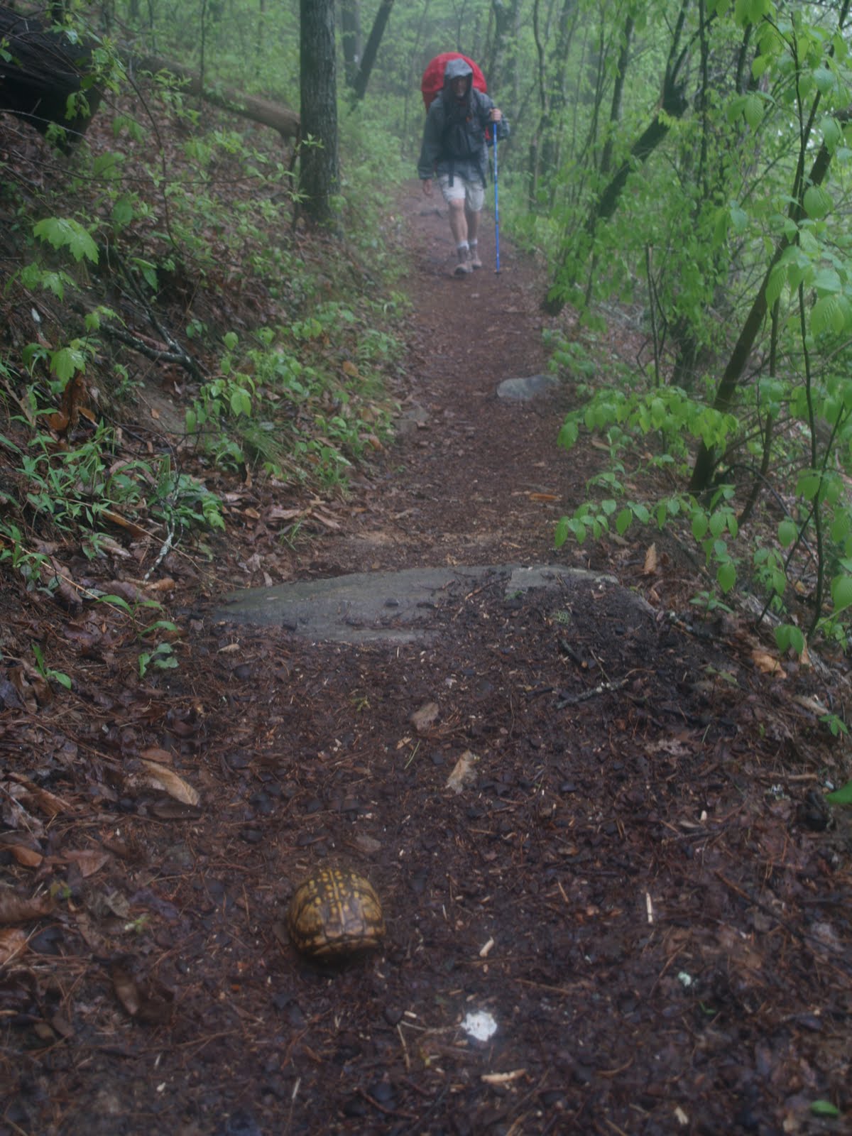
 Even though sleeping on a real mattress made for a good night's sleep, it seemed as if the morning came all too early. The gray light coming through the window told me it had to be some time after 6, so I grudgingly got out of bed, dressed, and then finished the last few pages of "Into the Wild". Downstairs, just before breakfast, I watched the forecast on the Weather Channel which was most unfavourable for this area. Outside it was rather chilly, the area blanketed in thick fog. The weather report indicated it was just a matter of time before the rain came.
About 7:30 the guests in the hostel were gathered around the breakfast table, but silence reigned. Everbody was wrapped up in their own thoughts or perhaps for some still half asleep, jarred out of their dreams by the call to breakfast. Once breakfast was served there started to be more chatter though somewhat subdued. Most of those at the table that morning were day or short section hikers. It was only me and the guy from Maine who were planning to do it all. The breakfast itself was delicious, something to really savour because it will be the last hot meal for me for a while going cookless as I do. People have asked why I don't carry a stove. The answer is that I'm not much of a cook at home so why try to become one on the trail. Besides, not having a stove saves a little weight as well as a good deal of time. There are plenty of pre-packaged foods to offer a hiker a wide variety of meals and Ramen noodles as well as oatmeal packets can be used with cold water.
After breakfast it was time to settle the bill, take the gear out to the van and load up. The trepidation and nervous energy began to build. Why this should be after already completing two long trails can only be attributed to the normal anxiety and excitement resulting from such an undertaking. We made two stops, one at Neels Gap and another at Horse Gap, before the remaining four of us were dumped at the Springer parking area. From there it's a one mile climb to the top where you find the official starting point of the Appalachian Trail on Springer Mountain. On the backside of the rocks there is a small shelf that holds the trail register. Logging in, I jotted down a few words about my hopes and how I was feeling. Then, the customary photo and a look at the bronze plaques that commemorate the trail's founding. There's supposed to be a view of the surounding countryside from here, but all I could see was a sheet of gray. Reversing direction, I passed going down those I had previously passed going up. My 2,181 mile journey had begun!
Upon returning to the parking area and then continuing north on the trail, I was surprised how often you walk alone after the initial crowding near Springer. There were periods of maybe an hour or more before coming across other hikers in front of me and then it was solitude once again. All around are the very first hints of spring---small green grasses, flower stems pushing up through the layer of leaves on the forest floor, tiny buds just starting to open on the branches of the trees. Yet everywhere there is a hush caused by the lowering gray clouds growing darker by the hour. By mid-afternoon the day is as dark as dusk and I walk as silently as possible hoping that my quiet passage would not disturb the heavens thus keeping the rain at bay. It wasn't until I had reached Woody Gap that the first drops began to fall. Attempting to reach the tent platforms at Lance Creek, I increased my pace and quickened my stride, but as the rain increased, I decided I had pushed my luck far enough. It was time to hunker down and make camp. A very wise choice as it turned out, for I had no sooner put up my tent than the deluge began, the storm hitting with enormous ferocity. Lightning crackled, thunder boomed and the rain pounded down.
It was only fifteen minutes into this downpour that I knew I was in trouble. So much water was falling that it was starting to build up and flow past my tent. I had to get back out there to save my tent from flooding. Armed with my small camp trowel and wearing only my underwear and running shoes I was back out in the elements, utterly drenched. Using stones from the fire ring, I quickly built a barrier around the front of my tent and then dug two small channels to divert the water on either side. The hasty construction job seemed to do the trick and once back inside, the tent stayed relatively dry. Quite miraculous really as it continued to rain heavily for the next eight hours. It was truly the worst storm I have ever witnessed in terms of rainfall and lightning strikes. I was to learn a few days later that this storm had spawned several tornadoes and killed 19 people in the surrounding area. And this was only my first day on the trail!
Appalachian Trail Commemorative Plaque
Springer Mountain, Georgia
Early Trail
Long Creek Falls


Short of Lance Creek to Chattahoochee Gap---April 16th
Last night a great torrential rain my first day on the trail.
My tent survived and I'm alive, at least it didn't hail.
Blood Mountain, Slaughter Creek---Just what have I begun?
The rain has ceased, the sky is blue and Lo!, the blessed sun.
The rain finally subsided around six. I snoozed for about an hour to try and make up for a semi-sleepless night before climbing out of the tent. During breakfast an Australian lady stopped by to see how I had weathered the storm. I showed her the improvised dam I had created and was happy to report that I'd got through fairly well considering the storm's severity and the massive amount of rain that had fallen. She on the other hand had not been so lucky. Her tent had been inundated and all her gear was wet. She must have been staying in the tent I saw in the swale at Dan Gap. Anyway, she was up early hoping to find a drier at Neels Gap.
While I began to pack up my gear, she continued down the trail. It was rather surprising to see a mouse jump out of my pack as the first items were being stuffed in the bottom. There wasn't any food there so the only thing I could figure is that it had used the pack as a safe haven during the worst of las night's torrent. More than welcome to it. Such a cute little thing with its white and brown markings. Finished packing, it was just a short jaunt to the camp at Lance Creek where other hikers were assessing the damage caused by the storm. It appeared to me as if the majority of those there had had flooding problems as well. Quite a miserable looking lot. To add insult to injury, one young couple had had their food taken by a bear at dawn. I was sorry for them, but it made me feel extremely fortunate. Is that wrong?
I caught up with the Aussie somewhere near Jarrard Gap and we were able to share some trail time and chat for a bit. I was extremely curious as to why a person from Down Under would fly half-way around the world to thru-hike the AT. She said she found out about the trail on the Internet, but was unsure of her mental or physical ability to actually complete it. To test herself, she had done a number of long hikes in Oz and some trails in Spain. Discovering a love for hiking and more confidence in her abilities along the way, she decided that she'd give the Appalachian Trail a go. She definitely wasn't your average Sheila.
I pushed on ahead on the long climb up to Blood Mountain and was rewarded with my first great views on this journey. Though still cold, the day was shaping up marvellously as the clouds had cleared and there was sunshine and blue skies. It was the perfect place for an extended snack break sitting on the rocks above the surrounding ridgelines.
On the descent to Neels Gap I met loads of weekend hikers and once there saw dozens of cyclists. The Walasi-Yi center is certainly a popular destination for recreational types. I was just happy they had a bathroom, which is one big difference from the Pacific Crest Trail that I've noticed in only a day and a half. Between the shelter privies and other bathroom facilities along the trail, the squat time in the woods is greatly reduced. Ha. I wasn't sure what to make of the "Shoe Tree", a large oak with a variety of shoes hanging from its branches. Did it represent victory or defeat? Were these northbounder boots tossed up on to the limbs signalling surrender already or were they southbounder footwear, a well-worn sacrifice to the tree gods for seeing them through this far; a new pair of shoes waiting for them in the Walasi-Yi center so they could finish in style? Maybe neither or maybe a little of both? Again, I'm not sure.
I passed a number of hikers climbing out of Tesnatee Gap. It seemed as if everyone and their dog were headed to Low Gap Shelter. When I arrived there the place was absolutely packed. There had to be over 50 people and at least 20 tents. Yikes! That was too much for me. I sat down on a fallen log, ate a quick meal and pushed on down the path. Another five miles and I was all alone at Chattahoochee Gap. Still a bit early in the day to stop hiking, but I'd packed my tent away wet and with the evening sun, if I set up now I was sure it would be dry by nightfall. Besides, there were other things that were a little damp that could use some dry time. Pitched in a little swale under a pine tree which effectively blocked the wind that was beginning to blow with increasing strength through the gap. When I lay my head down, it didn't take long before I was completely out. The sound of the stirring of the trees overhead ushering me into a blissful slumber.
Blood Mountain Shelter
Views from Blood Mountain
The Shoe Tree
Single Trekking Pole
Swallowtail Butterfly


My tent survived and I'm alive, at least it didn't hail.

Blood Mountain, Slaughter Creek---Just what have I begun?
The rain has ceased, the sky is blue and Lo!, the blessed sun.
The rain finally subsided around six. I snoozed for about an hour to try and make up for a semi-sleepless night before climbing out of the tent. During breakfast an Australian lady stopped by to see how I had weathered the storm. I showed her the improvised dam I had created and was happy to report that I'd got through fairly well considering the storm's severity and the massive amount of rain that had fallen. She on the other hand had not been so lucky. Her tent had been inundated and all her gear was wet. She must have been staying in the tent I saw in the swale at Dan Gap. Anyway, she was up early hoping to find a drier at Neels Gap.
While I began to pack up my gear, she continued down the trail. It was rather surprising to see a mouse jump out of my pack as the first items were being stuffed in the bottom. There wasn't any food there so the only thing I could figure is that it had used the pack as a safe haven during the worst of las night's torrent. More than welcome to it. Such a cute little thing with its white and brown markings. Finished packing, it was just a short jaunt to the camp at Lance Creek where other hikers were assessing the damage caused by the storm. It appeared to me as if the majority of those there had had flooding problems as well. Quite a miserable looking lot. To add insult to injury, one young couple had had their food taken by a bear at dawn. I was sorry for them, but it made me feel extremely fortunate. Is that wrong?
I caught up with the Aussie somewhere near Jarrard Gap and we were able to share some trail time and chat for a bit. I was extremely curious as to why a person from Down Under would fly half-way around the world to thru-hike the AT. She said she found out about the trail on the Internet, but was unsure of her mental or physical ability to actually complete it. To test herself, she had done a number of long hikes in Oz and some trails in Spain. Discovering a love for hiking and more confidence in her abilities along the way, she decided that she'd give the Appalachian Trail a go. She definitely wasn't your average Sheila.
I pushed on ahead on the long climb up to Blood Mountain and was rewarded with my first great views on this journey. Though still cold, the day was shaping up marvellously as the clouds had cleared and there was sunshine and blue skies. It was the perfect place for an extended snack break sitting on the rocks above the surrounding ridgelines.
On the descent to Neels Gap I met loads of weekend hikers and once there saw dozens of cyclists. The Walasi-Yi center is certainly a popular destination for recreational types. I was just happy they had a bathroom, which is one big difference from the Pacific Crest Trail that I've noticed in only a day and a half. Between the shelter privies and other bathroom facilities along the trail, the squat time in the woods is greatly reduced. Ha. I wasn't sure what to make of the "Shoe Tree", a large oak with a variety of shoes hanging from its branches. Did it represent victory or defeat? Were these northbounder boots tossed up on to the limbs signalling surrender already or were they southbounder footwear, a well-worn sacrifice to the tree gods for seeing them through this far; a new pair of shoes waiting for them in the Walasi-Yi center so they could finish in style? Maybe neither or maybe a little of both? Again, I'm not sure.
I passed a number of hikers climbing out of Tesnatee Gap. It seemed as if everyone and their dog were headed to Low Gap Shelter. When I arrived there the place was absolutely packed. There had to be over 50 people and at least 20 tents. Yikes! That was too much for me. I sat down on a fallen log, ate a quick meal and pushed on down the path. Another five miles and I was all alone at Chattahoochee Gap. Still a bit early in the day to stop hiking, but I'd packed my tent away wet and with the evening sun, if I set up now I was sure it would be dry by nightfall. Besides, there were other things that were a little damp that could use some dry time. Pitched in a little swale under a pine tree which effectively blocked the wind that was beginning to blow with increasing strength through the gap. When I lay my head down, it didn't take long before I was completely out. The sound of the stirring of the trees overhead ushering me into a blissful slumber.
Blood Mountain Shelter
Views from Blood Mountain
The Shoe Tree
Single Trekking Pole
Swallowtail Butterfly


Chattahoochee Gap to Campsite Near Blue Ridge Gap---April 17th
Kelly Knob and Cowart Gap, there are many ups and downs.
The gentle ground brings on the smiles, the steep brings on the frowns.
Wake up sleepy campers. Don't stay inside your tent.
The trail to you is calling and half the morning's spent.
I arose to a picture perfect day--- azure sky, bright sunshine and a little nip to the air to remind you that it is still spring in the mountains. With the trees void of leaves I could peer out and catch some lovely views of the surrounding landscape. How long this will last, I don't know. Possibly a few more weeks before the new leaves block out the sights and put me into "the green tunnel".
I came across my first instance of trail magic at Tray Gap. I saw the SUV and the people gathered around it, but thought it was probably somebody dropping off a group of hikers. I was just going to pass on by when one of the group happened to call me over with the clarion call of hikers, "Hey, trail magic!". Frankenfoot and his wife were the providers of a delightful smorgasbord including sausages, cheese, nuts, chocolates, pop tarts, chips and dip, sodas and more. Just help yourself. I stood around munching and listening to the idle conversation. The four guys were talking about how they'd started out at a ten-mile-a-day pace, but were now planning to up that to twelve or even fifteen. I had to smile inside, not because I hike much farther than that on a daily basis, but because they made it sound as if twelve miles was horribly difficult. Perhaps it was for them. Later in my journey I met a southbounder who was dying as he pulled into the shelter for the night and he had only done eight miles! I also heard Frankenfoot mention a female hiker, Snorkel, who had passed that way yesterday afternoon. She was attempting to set the women's AT unsupported record, having left Springer Mountain on April 15th. April 15th?! That's the same day I left, but I didn't remember seeing her. I was looking for some motivation on this trek and I believe I had just found it. I was going to try and catch this unknown hiker, but even if I couldn't, I would know what it was like to chase a record both physically and mentally. Feeling newly energized by this intriguing idea and the copious amount of food I'd just stuffed down my gullet, I left the trailside gathering, thanking them for their wonderful generosity and declaring that I was off to catch Snorkel. They all laughed thinking it was a good joke. Little did they realize how serious I was. My trailname is Will and I was going to earn it!
I pushed hard for the remainder of the day, driven by a newfound urgency. I'd wanted to resupply at Hiawassee, but after a brief stint at gaining a hitch, I pressed on. On that Sunday evening there was very little traffic and it was chancey at best to get there and back with the remaining daylight hours. What food I had left--- tortillas, starbursts, jelly beans and peanuts---would have to last me until Franklin.
Had a nice conversation with Deb out of Unicoi Gap while I was eating my late afternoon snack. She walks on the Appalachian Trail regularly on the weekends just to keep fit. I know if I had a National Scenic Trail in close proximity to my backyard, I'd try to take advantage of it as often as I could just like she does. A lot of hikers pulling up early at Plumorchard Gap Shelter, but I wanted to get in a few more miles before sunset, settling into the campsite beyond Blue Ridge Gap as the sun went down.
Shadow and Light
Tray Gap Trail Magic
An Open View


Thursday, July 28, 2011
Campsite Near Blue Ridge Gap to Winding Stair Gap---April 18th
Early on this morning I passed my first state line.
Goodbye to northern Georgia, hello to Caroline.
Coming out of Bearpen Gap a big laborious climb.
No problem getting to the top, just took a good long time.
Peanuts, Starbursts, jelly beans are all that now remain.
High time to go into a town and resupply again.
With an early rise, I arrived at the Georgia/North Carolina border at 8 this morning. Perfect excuse to drop the pack, take a few pics and snarf on breakfast tortillas. Although I was on the AT in Georgia for only three days before crossing the state line, the memory of these mountains will linger for a long time. Why? As Sade sings, "it's never as good as the first time". Georgia was my first experience on the AT, first climb, first descent, first storm, first trail magic, first meeting with other would-be thru-hikers, and though I didn't stay in one, my first time seeing what a shelter looked like. I suppose it can also be attributed to the thrill at the start of the journey before the familiarity of routine has set in.
A tenth of a mile later at Bly Gap, hikers were just getting a start to the day, some still crawling out of their tents while others were standing around rubbing sleep out of their eyes. Early mornings on the trail are a favourite time for me as I can generally be assured of walking undisturbed. Most of my best animal sightings occur during this time or during the waning hours of the day around dusk. It always makes my heart leap to surprise deer drinking from the small mountain streams.
One thing I like about the Appalachian Trail are the small wooden signs indicating the placename of where you're at. There's something very comforting about knowing where you are and how far it is to where you want to wind up. In my Thru-Hiker's Companion, I always look to see what names I should be looking for and try to calculate in my head approximately how long it will take me to get there. The strangest name so far was a side path called Chunky Gal Trail. How or why it earned this name is unknown to me, but I'm guessing there's a story there somewhere.
The steepest climb of the day was coming out of Bearpen Gap, one of those straight up the mountain kind that get the heart beating like a big bass drum, leave you winded in no time flat, and cause your calves to burn with the strain. Keep on pushing higher for with each passing step I know I'm getting closer to the top. Once at the top, I climb the stairs of an observation tower and marvel at the stunning views of rolling Appalachia all around me. As with any extraordinary spot along the trail, a great time to rest a bit while snapping photos and snacking.
The last of today's beauty spots was the area below Rock Gap that contains the Wasilik Poplar, the second largest poplar tree in the United States. It's well worth the half-mile trek down a side trail to see even though it is now dead. On the descent you pass a lovely patch of greenery with a bubbling mini-cascade convenient for topping off any empty water bottles. Once in the grove it doesn't take much imagination to envision what the tree looked like in its leafy grandeur. One of the forest's silent sentinels completing its long-time watch.
By the time I got back on the AT it was growing late and in my efforts to race the sun, I blew past Wallace Gap where I had hoped to find a place to camp. As the light grew dimmer and dimmer, I was literally jogging down the trail and with the tiniest flicker of remaining light I pulled into Winding Stair Gap, the site of tomorrow's hitch. Finding a nice flat spot tucked away in some rhododendron bushes on the side hill above the trail, I donned my headlamp and proceeded to make camp. Up at 7 a.m. in camp at 9 p.m., a mondo day of long miles, a few climbs, but mostly gentle grade. Snug in my sleeping bag, I reviewed the day's events in my mind. As I grew sleepier, approaching the boundary of unconsciousness, I recalled the guy who passed me on the trail today like I was standing still. Who was that masked man?!
Georgia/North Carolina Border
Gentle Terrain
Steeper Grade
Viewpoint
Rolling Hills of Appalachia
Babbling Brook
The Wasilik Poplar
Racing the Sun


Goodbye to northern Georgia, hello to Caroline.

Coming out of Bearpen Gap a big laborious climb.
No problem getting to the top, just took a good long time.
Peanuts, Starbursts, jelly beans are all that now remain.
High time to go into a town and resupply again.
With an early rise, I arrived at the Georgia/North Carolina border at 8 this morning. Perfect excuse to drop the pack, take a few pics and snarf on breakfast tortillas. Although I was on the AT in Georgia for only three days before crossing the state line, the memory of these mountains will linger for a long time. Why? As Sade sings, "it's never as good as the first time". Georgia was my first experience on the AT, first climb, first descent, first storm, first trail magic, first meeting with other would-be thru-hikers, and though I didn't stay in one, my first time seeing what a shelter looked like. I suppose it can also be attributed to the thrill at the start of the journey before the familiarity of routine has set in.
A tenth of a mile later at Bly Gap, hikers were just getting a start to the day, some still crawling out of their tents while others were standing around rubbing sleep out of their eyes. Early mornings on the trail are a favourite time for me as I can generally be assured of walking undisturbed. Most of my best animal sightings occur during this time or during the waning hours of the day around dusk. It always makes my heart leap to surprise deer drinking from the small mountain streams.
One thing I like about the Appalachian Trail are the small wooden signs indicating the placename of where you're at. There's something very comforting about knowing where you are and how far it is to where you want to wind up. In my Thru-Hiker's Companion, I always look to see what names I should be looking for and try to calculate in my head approximately how long it will take me to get there. The strangest name so far was a side path called Chunky Gal Trail. How or why it earned this name is unknown to me, but I'm guessing there's a story there somewhere.
The steepest climb of the day was coming out of Bearpen Gap, one of those straight up the mountain kind that get the heart beating like a big bass drum, leave you winded in no time flat, and cause your calves to burn with the strain. Keep on pushing higher for with each passing step I know I'm getting closer to the top. Once at the top, I climb the stairs of an observation tower and marvel at the stunning views of rolling Appalachia all around me. As with any extraordinary spot along the trail, a great time to rest a bit while snapping photos and snacking.
The last of today's beauty spots was the area below Rock Gap that contains the Wasilik Poplar, the second largest poplar tree in the United States. It's well worth the half-mile trek down a side trail to see even though it is now dead. On the descent you pass a lovely patch of greenery with a bubbling mini-cascade convenient for topping off any empty water bottles. Once in the grove it doesn't take much imagination to envision what the tree looked like in its leafy grandeur. One of the forest's silent sentinels completing its long-time watch.
By the time I got back on the AT it was growing late and in my efforts to race the sun, I blew past Wallace Gap where I had hoped to find a place to camp. As the light grew dimmer and dimmer, I was literally jogging down the trail and with the tiniest flicker of remaining light I pulled into Winding Stair Gap, the site of tomorrow's hitch. Finding a nice flat spot tucked away in some rhododendron bushes on the side hill above the trail, I donned my headlamp and proceeded to make camp. Up at 7 a.m. in camp at 9 p.m., a mondo day of long miles, a few climbs, but mostly gentle grade. Snug in my sleeping bag, I reviewed the day's events in my mind. As I grew sleepier, approaching the boundary of unconsciousness, I recalled the guy who passed me on the trail today like I was standing still. Who was that masked man?!
Georgia/North Carolina Border
Gentle Terrain
Steeper Grade
Viewpoint
Rolling Hills of Appalachia
Babbling Brook
The Wasilik Poplar
Racing the Sun


Winding Stair Gap to Wesser Bald Observation Tower---April 19th
The hitch to Franklin's easy. Dang right! Yeah, that's for sure.
With the help of a family roofin' man and a coffee connoisseur .
.
Up at the crack of dawn to be sure to be down at the road for the hitch at 7 a.m. I'm hoping to get a lift from some kind soul going to work this morning. A few minutes with my thumb out and a white pickup passes me by. A minute later I see it coming back up the road in the opposite direction and I knew I had my ride. The driver was part of a family roofing business (Dad was the owner) and since he was going through Franklin anyhow, he reckoned he ought to take me there too. Right kindly of you, mister. Because of all the severe weather recently, business was hopping. Everybody was out on calls and working OT to try and answer them all. Get while the getting's good.
With door to door service, he dropped me off right in front of the entrance to Shoney's. Wolfing down platefuls of breakfast food by 7:30, library at 9, outfitters at 10, supermarket resupply at 10:30, out on the highway at the edge of town by 11, just like clockwork. Ten minutes of trying my luck and a young man in a four door sedan pulls over. He works as an associate in a coffee co-op. Now I'm not a coffee drinker at all, but he was able to teach me a thing or two about the enterprise on our short trip to the trailhead. I especially liked the information about how the co-op works with local growers in third world countries so that both parties benefit from the endeavor. Good beans!
Back at Winding Stair Gap I stuck my head under a pipe that was shooting out spring water by the gallon and as the cold water ran over my hair and down my back I reflected on how lucky/blessed I'd been with a perfect resupply and turnaround. Elated, I gulped down a couple of liters of the liquid refreshment, topped off my bottle and returned to the trail.
I met a Swedish guy on the last part of the paved walk that led to Wayah Lookout and he had the same opinion as me about the two obese people walking past us to their car in the parking area. With the obesity problem at epidemic proportions in the U.S. and growing ever larger in other nations, why not move that parking lot a little further down the hill. Heck, at least they were out getting a (very) little excercise. Better that than sitting in the recliner at home. Felt sorry for the Swede when he told me he probably wouldn't be able to finish the entire trail before he had to go home. I asked him why and he told me he was hiking with his American friends who were averaging only 12 miles per day. He needed to average 20 to complete a thru-hike before his return flight. I wondered aloud if his friends were aware of this and he said they were, but were unwilling to push further, hike faster or stay on the trail longer. He really wanted to finish but if he were to do it, it would mean abandoning his friends and striking out on his own. I think he felt a little trapped and he'd have to make a tough decision in the very near future.
One thing I learned about my own hiking ability today is that I'm a strong climber compared to most others. I passed a good portion of hikers on the ascents today. To have legs shaped by the longer climbs of the Pacific Crest Trail last summer is a huge advantage. Yes, it's true that the Appalchian Trail has more ups and downs, but I know they are of much shorter duration than the 7,000 feet in elevation gain coming out of Saied Valley in Northern California. With that in mind I try to reach the tops without stopping.
I considered stopping at Cold Spring Shelter, but it was buzzing with flies so it wasn't a difficult decision to continue. Another evening of racing the sun. Would it set before I reached Wesser Bald Observation Tower or would I be standing on top taking pictures as it dipped below mountains on the horizon? An extremely close race and one that ended in a photo finish! I won, I won, I won and I've got the picture to prove it. Rolling ridgelines stretching out before me, the last rising to meet the orange sky. As the night closed in, I set up my tent on a small grassy patch at the tower's base. A cold wind began to blow and a nearly full moon rose slowly bathing the ground and trees in soft pale light.
Swinging Lick (Carved by some joker to look like Dick) Gap
Wayah Bald Lookout
Fire Ring at Trailside Camp
Rolling Ridgelines at Sunset
Moonlight and Branches


With the help of a family roofin' man and a coffee connoisseur
 .
.Up at the crack of dawn to be sure to be down at the road for the hitch at 7 a.m. I'm hoping to get a lift from some kind soul going to work this morning. A few minutes with my thumb out and a white pickup passes me by. A minute later I see it coming back up the road in the opposite direction and I knew I had my ride. The driver was part of a family roofing business (Dad was the owner) and since he was going through Franklin anyhow, he reckoned he ought to take me there too. Right kindly of you, mister. Because of all the severe weather recently, business was hopping. Everybody was out on calls and working OT to try and answer them all. Get while the getting's good.
With door to door service, he dropped me off right in front of the entrance to Shoney's. Wolfing down platefuls of breakfast food by 7:30, library at 9, outfitters at 10, supermarket resupply at 10:30, out on the highway at the edge of town by 11, just like clockwork. Ten minutes of trying my luck and a young man in a four door sedan pulls over. He works as an associate in a coffee co-op. Now I'm not a coffee drinker at all, but he was able to teach me a thing or two about the enterprise on our short trip to the trailhead. I especially liked the information about how the co-op works with local growers in third world countries so that both parties benefit from the endeavor. Good beans!
Back at Winding Stair Gap I stuck my head under a pipe that was shooting out spring water by the gallon and as the cold water ran over my hair and down my back I reflected on how lucky/blessed I'd been with a perfect resupply and turnaround. Elated, I gulped down a couple of liters of the liquid refreshment, topped off my bottle and returned to the trail.
I met a Swedish guy on the last part of the paved walk that led to Wayah Lookout and he had the same opinion as me about the two obese people walking past us to their car in the parking area. With the obesity problem at epidemic proportions in the U.S. and growing ever larger in other nations, why not move that parking lot a little further down the hill. Heck, at least they were out getting a (very) little excercise. Better that than sitting in the recliner at home. Felt sorry for the Swede when he told me he probably wouldn't be able to finish the entire trail before he had to go home. I asked him why and he told me he was hiking with his American friends who were averaging only 12 miles per day. He needed to average 20 to complete a thru-hike before his return flight. I wondered aloud if his friends were aware of this and he said they were, but were unwilling to push further, hike faster or stay on the trail longer. He really wanted to finish but if he were to do it, it would mean abandoning his friends and striking out on his own. I think he felt a little trapped and he'd have to make a tough decision in the very near future.
One thing I learned about my own hiking ability today is that I'm a strong climber compared to most others. I passed a good portion of hikers on the ascents today. To have legs shaped by the longer climbs of the Pacific Crest Trail last summer is a huge advantage. Yes, it's true that the Appalchian Trail has more ups and downs, but I know they are of much shorter duration than the 7,000 feet in elevation gain coming out of Saied Valley in Northern California. With that in mind I try to reach the tops without stopping.
I considered stopping at Cold Spring Shelter, but it was buzzing with flies so it wasn't a difficult decision to continue. Another evening of racing the sun. Would it set before I reached Wesser Bald Observation Tower or would I be standing on top taking pictures as it dipped below mountains on the horizon? An extremely close race and one that ended in a photo finish! I won, I won, I won and I've got the picture to prove it. Rolling ridgelines stretching out before me, the last rising to meet the orange sky. As the night closed in, I set up my tent on a small grassy patch at the tower's base. A cold wind began to blow and a nearly full moon rose slowly bathing the ground and trees in soft pale light.
Swinging Lick (Carved by some joker to look like Dick) Gap
Wayah Bald Lookout
Fire Ring at Trailside Camp
Rolling Ridgelines at Sunset
Moonlight and Branches


Wesser Bald Observation Tower to Cody Gap---April 20th
The path has turned to puddles and tiny muddy creeks.
The only ones out walking are A.T. hiking freaks.
Tender buds of flowers and light-green leafy shoots.
Just make sure that you don't trip on twisted, gnarly roots.
It started raining right after I broke camp. No real downpour but a steady fall of good-sized drops. I passed Wesser Bald Shelter, but there was nobody there. Met only one hiker on the trail because the rest, as I would soon discover, were hunkered down at the Nantahala Outdoor Center (NOC). There were about a dozen or so hikers milling around. Some were opening resupply boxes they'd sent to this location, others were in the shop looking to purchase an essential item or two, while another few were simply biding their time waiting for the rain to let up. I took the opportunity to grab a snack and find out what their plans were. Most of those I spoke with were hoping to make it to Sassafras Gap Shelter. With that in mind, I definitely wasn't going to stay there tonight. Sounded as if it would get very crowded. Besides, I really hadn't planned to stay in shelters anyway, avoiding them if I could. One section on Whiteblaze.net was a survey of past thru-hikers asking them what they would do differently if they had the chance to do the trail again. Several responded that they would spend less time in the shelters for a variety of reasons. I took that to heart and have found plenty of places just off the trail that are more than suitable for my little tent.
The rain tapered off at 11 a.m. and I was hoofing it up away from the NOC before the rest of the groups. There were a good number of long, steep climbs today. Raisins, a young asian hiker who gained his trailname by starting at Springer with four pounds of raisins in his pack, challenged me on a couple of them. He attacked the climbs with speed, passing me with little problem, but it was only a matter of time before I caught and passed him as he had stopped to rest and catch his breath. A bit of leapfrogging ensued in the remainder of the afternoon before we met again at some picnic tables at Stecoah Gap. Snacking again, we had a chance to talk about doing thirty mile days, which I thought he was more than capable of. He passed me again on the uphill out of Sweetwater Gap, but stopped for the day at Brown Fork Gap Shelter, a pre-arranged place to meet other hikers he had fallen in with and today had far out-paced. I went three miles further to a camp at Cody Gap, where I met two older section hikers out of upstate New York who were enjoying the last few days of a week-long trek. While chewing the fat with them, five more hikers arrived at differing times, two couples and a lone traveler. Time to stake claim to my piece of flat ground. Huddling in my tent I was hoping it wouldn't rain and that the bears would stay away.
Gray and Purple Dawn
Turtle and Trekker

Cody Gap to Russell Field Shelter---April 21st
For breakfast I have Pop Tarts on which I do subsist.
Then back on trail I disappear like a gorilla in the mist.
Got to camp quite early, well before it's dark
To stay at Russell Shelter in Great Smoky National Park.
It started raining early in the morning, but faded away just as I needed to get up, packed and away. Mostly a descent to Fontana Dam on the early trek. The trees are still bare at the 3,000 foot level, but the forest floor is now a carpet of greenery interspersed with the whites, yellows and pinks of wildflowers. At lower elevations near the dam, all the trees had their light green leaves of spring.
I took my morning break at the "Fontana Hilton" and was lucky to find the last backcountry permit for the Smokies on a shelf there. Not that anybody asked to check it while I was in the park, but better safe than sorry when it comes to picking up a $125 fine if you're asked for it and can't produce it. While filling the water bottle at the restroom and using the facilities, I saw a huge brown spider crawling on the tiled floor. Would have hated to meet that thing in the shower! Reminded me of a few lines from an Australian song about spiders and dinkum dunnies:
There was a Redback on the toilet seat when I was there last night
I didn't see it in the dark, but boy I felt it's bite
Now here I am in hospital a sad and sorry sight
God, curse that Redback spider on the toilet seat last night!
Fontana Dam itself was an engineering wonder, staking claim to the largest of its kind east of the Mississippi. It was a dizzying experience to look down over the railing and into the spillway several hundred feet below. Still too early in the season for many travelers so the visitors center was closed. Had to make do reading the information boards located at different points around the area.
Quite a milestone to pass the signs indicating that I had just entered Great Smoky Mountains National Park. I'd looked forward to being once again in one of the nation's premier parks, especially having the opportunity to hike through it. The last time I'd passed this way was on a road trip in the summer before my senior year at university.
On the climb up to Shuckstack, I sneaked up on a few people without them knowing it. Wrapped up in his own thoughts, the first guy I passed was muttering something about broken promises and issuing a few commands to go @*%# themselves to whomever had done him wrong. I guess he was using the trail time to exorcise a few demons. The first group I passed was discussing the awesome possibility of doing a 20-mile day. Good for them. One rather large individual (300+ pounds) was huffing and puffing at a small bend in the trail near a stream crossing, vowing to himself that he would cut down on the number of cheeseburgers he consumed. I later learned his trailname was Chicken Wing and that he was using the hike as a way to lose weight. Supposedly, he had already dropped significant pounds, but he still had a long way to go. If he sticks with it, the trail will definitely do its part to help him shed the fat.
Mollies Ridge Shelter was much like Cold Spring Shelter a few days ago, plagued by flies. Luckily for me Russell Field Shelter was much better. When I arrived around four in the afternoon, there was only one person there, but by the time it grew dark, the place was pretty much full. Why had I stopped early and at a shelter no less? Simple, really. Park regulations require you to stay in shelters while in the boundaries of the park. A bit of snoring during the night, but nothing too bad to prevent me from sleeping.
Green Carpet and Wildflowers
Then back on trail I disappear like a gorilla in the mist.
Got to camp quite early, well before it's dark
To stay at Russell Shelter in Great Smoky
 National Park.
It started raining early in the morning, but faded away just as I needed to get up, packed and away. Mostly a descent to Fontana Dam on the early trek. The trees are still bare at the 3,000 foot level, but the forest floor is now a carpet of greenery interspersed with the whites, yellows and pinks of wildflowers. At lower elevations near the dam, all the trees had their light green leaves of spring.
I took my morning break at the "Fontana Hilton" and was lucky to find the last backcountry permit for the Smokies on a shelf there. Not that anybody asked to check it while I was in the park, but better safe than sorry when it comes to picking up a $125 fine if you're asked for it and can't produce it. While filling the water bottle at the restroom and using the facilities, I saw a huge brown spider crawling on the tiled floor. Would have hated to meet that thing in the shower! Reminded me of a few lines from an Australian song about spiders and dinkum dunnies:
There was a Redback on the toilet seat when I was there last night
I didn't see it in the dark, but boy I felt it's bite
Now here I am in hospital a sad and sorry sight
God, curse that Redback spider on the toilet seat last night!
Fontana Dam itself was an engineering wonder, staking claim to the largest of its kind east of the Mississippi. It was a dizzying experience to look down over the railing and into the spillway several hundred feet below. Still too early in the season for many travelers so the visitors center was closed. Had to make do reading the information boards located at different points around the area.
Quite a milestone to pass the signs indicating that I had just entered Great Smoky Mountains National Park. I'd looked forward to being once again in one of the nation's premier parks, especially having the opportunity to hike through it. The last time I'd passed this way was on a road trip in the summer before my senior year at university.
On the climb up to Shuckstack, I sneaked up on a few people without them knowing it. Wrapped up in his own thoughts, the first guy I passed was muttering something about broken promises and issuing a few commands to go @*%# themselves to whomever had done him wrong. I guess he was using the trail time to exorcise a few demons. The first group I passed was discussing the awesome possibility of doing a 20-mile day. Good for them. One rather large individual (300+ pounds) was huffing and puffing at a small bend in the trail near a stream crossing, vowing to himself that he would cut down on the number of cheeseburgers he consumed. I later learned his trailname was Chicken Wing and that he was using the hike as a way to lose weight. Supposedly, he had already dropped significant pounds, but he still had a long way to go. If he sticks with it, the trail will definitely do its part to help him shed the fat.
Mollies Ridge Shelter was much like Cold Spring Shelter a few days ago, plagued by flies. Luckily for me Russell Field Shelter was much better. When I arrived around four in the afternoon, there was only one person there, but by the time it grew dark, the place was pretty much full. Why had I stopped early and at a shelter no less? Simple, really. Park regulations require you to stay in shelters while in the boundaries of the park. A bit of snoring during the night, but nothing too bad to prevent me from sleeping.
Green Carpet and Wildflowers
Russell Field Shelter to Mt. Collins Shelter---April 22nd
When I arrived at Clingmans there wasn't much to see.
Everything was shrouded in a fog of mystery.
The wind howling outside and drops of moisture on the shelter roof were not welcoming sounds for an early rise. Certainly mornings like this take a strength of will to overcome the urge to crawl lower into a warm sleeping bag and forge out into the inclement weather. A large part of the day was spent trekking in the thick fog decked out in my cold weather gear, but truth be told the only water to fall was from the branches that had been soaked in mist enough to create a steady dripping. Clingmans dome was socked in so I didn't even bother going up to the observation platform. Just my luck that after I'd passed by, the sun started to break through making it much more pleasant in the late afternoon/early evening than it had been earlier. Hiking through sections of dark spruce and fir with everything on the ground covered in green moss was the highlight for me.
Mt. Collins Shelter was pretty full when I got there with thru hikers, section hikers and even a couple of people who had hiked in from Newfound Gap to support their friends who were hiking the trail. Fortunately there was still a spot for me for I must admit that battling the cold all day had left me a little chill. Can't wait to crawl into my sleeping bag and warm up. If I happen to drift off to sleep in the process, all the better. A lot of the talk I overheard in the evening centered around resupply, zero days and accommodation. A group of younger guys were talking about hitting the town hard and getting all shit-faced, laughing and saying how cool that would be. BAH! That's the type of stuff that gives hikers a bad rep among town's folk and personally, I don't want to be associated with that kind of behaviour at all. If you're going to drink, please drink responsibly.
Departure from Russell Field Shelter

Mt. Collins Shelter to Tri-Corner Knob Shelter---April 23rd
'Twas Gatlinburg in late Ap-Ril
Sat down at Shoney's to eat my fill
Then on to Food King to get my resupply
Hitched back to Newfound Gap you see
Arrived at Icewater Spring by three
Pulled in to Tri-Corner Knob for some shuteye. (Sung to tune of A Boy Named Sue)
In order to get to Newfound Gap relatively early I was up at 5 and out of the shelter by 5:30. Using my headlamp to light the trail in front of me, I walked at a slower pace through the morning mist. With the first light of dawn, the mist began to dissipate and I began to see a faint blue in the sky above me. It was shaping up to be one fine day. Arriving at the gap just after sunrise, I was greeted by two young Chinese women who wanted to have their picture taken with me, declaring that I was a real American hero. I had to laugh at that declaration, but was more than happy to strike a pose. Turns out they are attending an MBA course at Western Missouri University and have eight months left on their student visas before they have to return to China. They were in the park as part of a larger group and were enjoying their spring break immensely. Their enthusiasm for the nature around them was infectious.
I got my ride into Gatlinburg without even having to hitch. The driver/co-owner of the Grand Prix Hotel was dropping hikers off at Clingmans Dome and Newfound Gap. The trip up from town you have to pay for, splitting the fare between whoever's getting a ride to the top. However, getting a lift into town is free of charge. Not many hikers can take advantage of the offer because it's 4.5 miles from Mt. Collins Shelter and he heads back into town no later than 8 a.m. The early bird gets the worm!
After being dropped off, my first stop was at Shoney's to sample the breakfast buffet. Five plates fully loaded and there may have been a sixth, but I lost my appetite when I looked down and saw a big cockroach crawling along the carpet past my booth. I think that's enough of Shoney's for a while. Next stop was going to be a resupply at Food King on the edge of town, so I hopped on the blue-line trolley that would take me there. At 50 cents per ride it was a great way to get around. Shopping done, it was back downtown to find a camera shop because my battery needed charging. A bit pricey for a jolt of electric juice but it should last me for the remainder of the hike. All in all, I liked Gatlinburg very much. With its carnival atmosphere, entertainment and novelty shops it made a nice contrast to the solitude and austerity of the trail.
I'd heard that the hitch out of Gatlinburg could be troublesome, for many of the people entering town are not the locals, but vacationers that have little desire to assist a scruffy looking vagabond with a pack on his back. Luckily, that wasn't my experience. I had barely raised my thumb before a nice family from Wisconsin made a U-turn and offered me a ride. They weren't exactly sure where I wanted to go in the park, so they said I'd have to guide them. They went well out of their way to drive me back to Newfound Gap because the camp they were staying at was down a different road. "Ah, hell," said the dad, "it's no bother. We'll stop there too and take in the views". How wonderful of them!
I set my pack down near the mileage sign next to the trail while I made a final check of my gear. Katahdin- 1,972 it said. Looking on the bright side, at least I was below 2,000. :-) When I looked over my shoulder I noticed a fair number of people had gathered round. A small girl was whispering into her mother's ear and I heard the mum say, "Why don't you ask him?". I looked at the little girl and said, "What do you want to know?". She was wondering if I was going all the way, such a long distance. I replied that I sure hoped to. Well, with that opening, more and more questions came from the group about trail life, animal encounters, resupply, daily mileage, etc. Again, one of the times on trail when a slight feeling of celebrity creeps in. Most seemed genuinely interested in and somewhat astounded by the tales of a thru-hiker. I was happy to share.
All questions eventually being answered, I hoisted my pack onto my back and was once more moseying down the trail. It truly was a gorgeous day and high on the ridgeline I had views to my heart's content. These are some of the highest points on the whole of the AT and with the weather the way it was, it was easy to enjoy them. Along the way, I met an elderly couple who had seen me packing it away at the buffet. The lady suggested that if I didn't have a trailname already, perhaps Five Plates would do for one. I guess you never know who's watching!
As with all shelters I've stayed in, Trinarcopiate. Now, I fully understood why the consensus among many past thru-hikers was to spend less time in the shelters. Unbelievable!
Newfound Gap at Dawn
A Real American Hero :-)
High Country
Great Smoky


Tri-Corner Knob Shelter to Brown Gap---April 24th
Easter Morn Wild Child and I came down to Davenport Gap.
Three tables filled with food and drink. Is heaven on my map?
Thought I was the first one out of the shelter this morning (wanted to be after last night's death rattle snoring and drug emporium), but came across Wild Child further down the trail. She is an experienced ultra-lite hiker who started the AT with her husband before he picked up a knee injury forcing her to continue on her own. A difficult adjustment mentally and she admitted that at times it had been hard to carry on without him. She also knew of Snorkel, telling me that they had spent some trail time together. She said that Snorkel was not a particularly fast hiker but with steady pace and determination could certainly put in the daily mileage to set the new record. We picked up a thread of conversation and continued it all the way on the long 4,500 foot descent to Davenport Gap which helped the time in the trees fly by. On arrival, trail magic was waiting for us as Section 11 and other trail enthusiasts had set up a feeding station on this beautiful Easter morn. Three tables laden with a rich assortment of food for a hiker feast and foldable camp chairs spread all around to help us rest our weary legs. As soon as I sat down I was asked if I wanted a quesadilla cooked to order. I think I took a moment to answer, the impression of it all causing me to just sit there stunned with my mouth open. I hope I wasn't drooling! Ha ha. The trail angels on the PCT are great, but this kind of generosity, meeting you out on the trail for a buffet, was something I'd never experienced before. In addition to the Mexican food, there was a blueberry bagel sandwich, chips and salsa, Snickers bars and Chips Ahoy cookies, washed down with Gatorade and ginger ale. Plenty of pleasant conversation swapping trail stories as well. It must have been a good time for Wild Child as well because she met her hubby at the picnic. The news about his knee wasn't promising though because it appeared as if he had torn one of the ligaments, which meant it would be some time before he could be anything more than support at some of the trail towns and road crossings. Looking back now, I wonder if she continued or whether they eventually decided that it just wasn't their year and to try it again when he'd healed up. Anyway, needless to say, it was very hard to pull myself away, nevertheless, I had to continue. Mile Nazi! HA! Making my exit, I thanked everyone profusely and then hit the rise on the other side of the road.
A long steady climb eventually took me back up to the ridge where it was the usual ups and downs of knobs and gaps. Since I had passed out of Great Smoky National Park boundaries I didn't have to overnight at a shelter any longer. I camped solo in Brown Gap and was thankful for the evening solitude after the crowded shelters of the past few days. The cheerful chirping of crickets ushered in the night and brought and end to a truly wondrous day.
Dining at Davenport Gap
The Gentle Path
Spring Flowers


Brown Gap to Rich Mtn. Fire Tower Side Trail---April 25th
Butterflies and birdsong seen and heard along the way
A gentle breeze, the sun o'er head. My, what a glorious day!
Convinced that we're alone now, us vagabonds, we three
The best of partners I could have---I, myself and me.
There were three young teenage hikers who walked past my camp at Brown Gap last night at 9 o'clock. Didn't know their reason for pressing on after dark, but discovered it as I reached the top of Max Patch and found them sound asleep in their sleeping bags, sawing logs as the soft light of morning settled on the summit. While I sat down on my own patch of grass and enjoyed my breakfast, they didn't even stir. I left them undisturbed in their blissful slumber, completely unaware of my passing.
A magnificently relaxing day going up and down with no climbs too troublesome nor descents too steep. I was alone on the trail for the most part except for a few couples with dogs. In the course of time, I found myself in Hot Springs, North Carolina, resupplying at the Dollar General and checking in with my sister via e-mail at the town library. Bought a couple of books there to give me something to read and keep my mind occupied in camp. Nothing is quite as good at helping me wind down at the end of a long day than a chapter or two. I'd contemplated taking a rafting trip while in town, but felt the experience would suffer in comparison to my time shooting the rapids on the Nile, so decided to skip it.
Leaving town along the bank of the French Broad River, I saw the rafters in their life vests and headgear having a good time in the whitewater. I loved hearing their excited shouts as they dropped a few feet over a category three, but for my money, the river was much too tame. Eventually the trail reached a series of switchbacks that climbed up out of the valley, offering great views of the river, the town and the surrounding mountains. Later on there was a small dam near Miller Ridge, a nice, interesting place shaded by tall trees with a couple of benches inviting to a foot-worn traveler. Little secluded spots like this are perfect for taking snack breaks or catching your breath.
It's a great sensation to feel so strong on the trail like I did today. Almost super human, could go all day and not feel tired or sore. Even with the lengthy, hour-long stop in town, it was my second longest mileage day thus far. Jon, a.k.a. "Swamp Tromp", my hiking buddy from the Florida Trail, can't believe how far I've gone already. He also told me that the guy from Maine I stayed with in the Hiker Hostel in Dahlonega has decided to pack it in. He was only ten days on the trail, but I guess it's better to figure out early that thru-hiking isn't for you than mid-way through a 2,000 mile journey. Sometimes there's a big gap between the dream of hiking a long trail and the reality that you have to face each day. That's one reason there is such a high attrition rate in the first two weeks.
Sleepyheads at Max Patch
Floral Forest Floor
Rafting on The French Broad
Climbing the Switchbacks


Rich Mtn. Fire Tower Side Trail to Big Flat---April 26th
Come ye weary hikers just beyond the N.C. border.
Drop your pack, take off your shoes---refreshing drinks to order.
Belgian waffles, tasty stew seem like such a dream.
Brownie, Pound Cake , Apple Pie---all come with ice-cream.
Headstones in memoriam are laid just off the trail
Reminding us that in the end all our bodies fail.
This morning I passed a lot of people in tents at Hurricane Gap and at Spring Mountain Shelter. We sort of all joined up at Allen Gap for the best trail magic so far. A typed note attached to a sign near Allen Gap informed hikers of a generous offering down the road to the right and up the first driveway past the North Carolina border. Everyone, with eager anticipation, made the short detour, coming to the porch of a lovely log home where, after dropping packs and removing shoes, we were cordially invited inside. Seated in order of arrival around a large dining room table, our gracious hosts, Hercules and Fal, introduced themselves. In turn, the hikers gathered round the table became acquainted. The funniest thing for me was to see the look of those who had chosen root beer as their beverage when they were asked if they'd like it in a frosty mug with ice cream. The initial reaction was to sit there stunned as if their ears hadn't heard the question properly. After they realized they weren't hallucinating, a broad grin broke out on their faces. Fal kept all of us supplied with Belgian Waffles and when Hercules wasn't pouring drinks he was dishing out bowls of hearty stew. Just when we thought things couldn't get any better, we got the dessert menu, which caused our mouths to begin watering all over again. Incredible. As the meal was winding down, Hercules and Fal shared a message of faith with us and for those that were so inclined, a variety of Christian literature was offered free of charge. As I'm always looking for something to read on trail I selected one from the collection. Spent a little over an hour as an honored guest in their home and as I was leaving, was asked to send a photo from Katahdin marking the end of my trek if I got that far. That's something I'll have to be sure and do.
A long climb out of Allen Gap gaining 2,000 feet in the process. The walk along the exposed ridgeline was slow going, scrambling up and over rocks. I passed so many people as I walked past three different shelters on my way to Big Flat that I reckon I must be pushing my way up into the main pack. This was my twelfth day out, but I'm doing about twice as many miles as the average hiker. I don't really stop to talk much. Sometimes I catch a few trail names, but so many are easily forgotten and at this pace I'm positive I'll never see those I've passed again.
A strange thing coming across headstones alongside the trail. The most prominent were those of William and David Shelton who lived in North Carolina, but fought with the Union Army. Returning to a family gathering during the Civil War, they were ambushed and killed by Confederate troops. Other grave markers bore names of those who in their lifetimes had a special affinity for this section of the trail. On passing I kept a respectful silence while feeling a few pangs of melancholy.
Allen Gap Trail Magic
The North Carolina Border
Rocky Ridgeline
Shelton Graves


Drop your pack, take off your shoes---refreshing drinks to order.
Belgian waffles, tasty stew seem like such a dream.
Brownie, Pound Cake
 , Apple Pie---all come with ice-cream.
Headstones in memoriam are laid just off the trail
Reminding us that in the end all our bodies fail.
This morning I passed a lot of people in tents at Hurricane Gap and at Spring Mountain Shelter. We sort of all joined up at Allen Gap for the best trail magic so far. A typed note attached to a sign near Allen Gap informed hikers of a generous offering down the road to the right and up the first driveway past the North Carolina border. Everyone, with eager anticipation, made the short detour, coming to the porch of a lovely log home where, after dropping packs and removing shoes, we were cordially invited inside. Seated in order of arrival around a large dining room table, our gracious hosts, Hercules and Fal, introduced themselves. In turn, the hikers gathered round the table became acquainted. The funniest thing for me was to see the look of those who had chosen root beer as their beverage when they were asked if they'd like it in a frosty mug with ice cream. The initial reaction was to sit there stunned as if their ears hadn't heard the question properly. After they realized they weren't hallucinating, a broad grin broke out on their faces. Fal kept all of us supplied with Belgian Waffles and when Hercules wasn't pouring drinks he was dishing out bowls of hearty stew. Just when we thought things couldn't get any better, we got the dessert menu, which caused our mouths to begin watering all over again. Incredible. As the meal was winding down, Hercules and Fal shared a message of faith with us and for those that were so inclined, a variety of Christian literature was offered free of charge. As I'm always looking for something to read on trail I selected one from the collection. Spent a little over an hour as an honored guest in their home and as I was leaving, was asked to send a photo from Katahdin marking the end of my trek if I got that far. That's something I'll have to be sure and do.
A long climb out of Allen Gap gaining 2,000 feet in the process. The walk along the exposed ridgeline was slow going, scrambling up and over rocks. I passed so many people as I walked past three different shelters on my way to Big Flat that I reckon I must be pushing my way up into the main pack. This was my twelfth day out, but I'm doing about twice as many miles as the average hiker. I don't really stop to talk much. Sometimes I catch a few trail names, but so many are easily forgotten and at this pace I'm positive I'll never see those I've passed again.
A strange thing coming across headstones alongside the trail. The most prominent were those of William and David Shelton who lived in North Carolina, but fought with the Union Army. Returning to a family gathering during the Civil War, they were ambushed and killed by Confederate troops. Other grave markers bore names of those who in their lifetimes had a special affinity for this section of the trail. On passing I kept a respectful silence while feeling a few pangs of melancholy.
Allen Gap Trail Magic
The North Carolina Border
Rocky Ridgeline
Shelton Graves


Big Flat to Curley Maple Gap Shelter---April 27th
Violently the trees are swaying, a mighty wind doth blow.
Hope and pray the snapping branches don't fall on tents below.
The wind was fair gusting through the trees as I was breaking camp today, which made it a tricky task to get my tent folded up and secure. The gale continued as crouching low to create a low profile I forged my way above the treeline to the top of Big Bald. The force of the wind at the top made it quite difficult to keep my feet as the swirling blasts knocked me off balance. The dark gray sky threatened rain that never came and by mid-afternoon the sun made a brief appearance.
I met a young female hiker at Bald Mountain Shelter as I took some respite from the wind. She'd had to take a few weeks off the trail because of a case of pneumonia. She'd jumped back on as soon as she felt well enough and had picked up the trail name Wheezy because of her rough breathing. Quite a lesson in perserverance and despite her setback, she was full of youthful optimism, an ever present smile on her face and a twinkle in her eye. There were a couple of Germans that I spoke with as well. It's always nice to see a foreign contingent enjoying the great American outdoors. Both were avid hikers that had made the flight across the Atlantic because "there is nothing quite like this in Europe".
A steep descent into the Nolichucky River Valley left me on the outskirts of Erwin, Tennessee, my resupply stop. I started walking along the road into town and without even sticking my thumb out to indicate that I needed a lift, a guy in a pickup truck pulled onto the shoulder ahead of me and offered me a ride into town, dropping me off at the good old Dollar General. A short time in the shop to buy what I'd need for the next few days and I was back on the road out of town. Same thing happened, another local asking me where I'd like to go without even trying to hitchhike. Got into the cab of his pickup and, lickety split, I was back at the trailhead. All I could do was thank these kind strangers and shake my head almost in disbelief at my good fortune. Experiences like this tell me that there are a lot of kind-hearted people out there. Hitching can be a dreaded and in some very few instances a dangerous thing, but by and large the people I've met who've given me rides have been so very nice.
Four trail miles was the distance from Erwin to Curly Maple Gap Shelter and it was well nigh dark by the time I reached it. Pulling in late, there was absolutely no room as hikers were packed in like sardines, lying shoulder to shoulder. The tent pads were all taken as well, so I was left trying to find a suitable space somewhere to camp. I found a small space between a tall pine and the arching branches of rhododendron bushes. A tight squeeze to be sure, but there were no other options. I made sure everything was battened down because the word in Erwin was that there is supposed to be a rough round of thunderstorms tonight. Fell asleep feeling a tad uneasy.
Blowing on Big Bald
Butterfly Mid-Afternoon
Nolichucky River Valley


Curley Maple Gap Shelter to Ash Gap---April 28th
Thunderbolt! O, Flash of light! How frightfully I fear thee.
I love to watch your fireworks show, just simply not so near me.
The rain was minimal last night, but there were violent gusts of wind and nearby lightning strikes that scared me just a little. The worst thing was hearing a big thud next to my tent and actually feeling the vibrations from the impact on the ground. When I got out of the tent this morning a large branch was lying on the ground no more than 20 yards away. Wow! Someone's looking out for me.
I was the first to leave camp, but for some reason, perhaps due to a less than restful night, I started really slow, not feeling my best at all. The storm must have been part of a cold front because it was very chilly all day. Surely a part of the cold could be attributed to walking in a frosty morning mist accompanied by a constant wind. That combination just seemed to suck the warmth right out of me and most of the day my hands were red and numb.
The highlights of the day were Beauty Spot, another bald with nice views though somewhat limited because of today's weather, and Unaka Mountain, where the trail passed through a super red spruce forest. The mist swirling around the trunks and treetops created an otherworldly atmosphere as I strode beneath the boughs. The climb up to Ash Gap was also quite nice and finding a primitive camp there I decided to stop for the day. I was a mile and a half from Roan High Knob shelter, but since the Thru-Hikers' Companion said that "Roan Mountain is arguably the coldest spot, year-round, on the southern A.T.," I figured it might be a tad warmer where I was. A wonderful feeling to be huddled in my down sleeping bag as the sun is sinking in the west. I'm finally warm! :-)
My final thought of the day was "Where is Snorkel?" I've been doing fairly well at logging the miles but she may be doing just as many or maybe more. I think back to my PCT days when Steve and Kristen were a day behind me for the whole state of Oregon. If hikers are keeping the same pace, one could be a mile ahead of the other and they'd never meet. It's a matter of gaining a few miles a day if I am to catch up. If we do meet, it will most likely be in Virginia.
Unaka Mountain
Sun Sinking Low


Ash Gap to Stream Beyond Walnut Mountain Road---April 29th
A vicious biting wind, fingers frozen red and raw.
Within an hour with sunshine power they begin to thaw.
At Bradley Gap a mountain gale howling in my ears.
Stumbling, tripping, tumbling as if I had too many beers.
Nobody a ride would give, at least that's how it seemed
Until a pick-up truck stopped by, Roan Mountain is redeemed!
This morning's walk up to Roan High Knob was simply frigid, the freezing humid air nipping at my fingertips, chin and nose. Despite wearing glove liners, my fingers were quickly rendered numb. Icy drops from the gathered mist were falling from the evergreens.
As the day progressed the wind blew away the mist and on Little Hump Mountain it nearly did the same to me. No exaggeration! I was getting hammered so hard by the gusts that at one point I just sat down and lay low to the ground. The wind whipping past my head had given me a bit of a brain freeze, almost as if I was light-headed due to the cold air. On these treeless heights there is little to no protection from the elements. The best you could do is crouch down beside a small group of rocks and hope they break the force of the wind. The most sensible thing to do is get back below treeline, but that's at least an hour long stretch between Little Hump and slighty higher Hump Mountain. I don't rightly know if they earned those names because of their geographic shape or because of the profile of the hikers fighting their way over their summits. Looking like a spastic Quasimodo I stumbled onwards through the buffeting, the gusts reaching their highest speeds as they rushed through Bradley Gap. What does it take to qualify as hurricane force? It was with a great big sigh of relief when I finally dropped down into the stand of trees on the back side of Hump Mountain and could walk normally again.
At Apple House Shelter I met an older hiker that mentioned encountering a young lady on the trail who was hiking very fast. Plying him with questions, I could reasonably assess that Snorkel was probably about seven miles ahead of me. That was some very good news to get. I was closing the gap. Two weeks ago I'd been nearly a full day behind. Now, three hundred plus miles later, I only trailed her by three hours. Bad news was that I had to go into Roan Mountain, Tennesee to resupply and I wasn't sure how long it would take.
Unfortunatlely, I didn't get a ride into town, which wasn't that bad because at 2.4 miles from the road crossing it was less than an hour's walk to the Dollar General. The thing that really irked me were the cars that passed by and honked, not out of any greeting because there was no accompanying wave. I was doing my best to stay on the farthest part of the shoulder away from the traffic, so I didn't feel as if the blaring horns were necessary. Thought I'd have to hoof it all the way back too, but three young guys in an old beat-up truck pulled over and told me to hop in the back. They'd given rides to AT hikers many times before and knew where to drop me off. Thanks guys. Lesson: Some people honk and some people help.
The remainder of the day offered pretty easy miles as there was a mere 700 foot elevation difference over the next 11 miles. Mountaineer Shelter was in a nice location just up from the waterfall that bears its name. I went there for a rest break and a fuel stop, gobbling down some granola bars as one of the people there told me about a hiker trying to break a record. He'd met her where a side trail leads to a small waterfall and was surprised that she only filled up on water from the nearby stream, not bothering to go the half mile to check it out. I had to laugh at that because I'd done the exact same thing. It's not that I haven't been on some side trails because I have, the ones to Wasilik Poplar and Long Creek Falls as examples. However, I didn't feel the need to see that one. He was even more astonished when I told him that I was trying to catch up with her. The final thing that left him flabbergasted was the fact that he'd been on the trail for a month more than I had. Shaking his head and laughing, he wished me luck as I departed. Snorkel was only two hours ahead.
Another hour and a half of walking and I found a nice little camp right beside a stream. A good water source giving me a chance to wash off and drink my fill. The sound of the water flowing over the rocks lulled me into a sound sleep.
Grassy Ridge
Little Hump Mountain


Subscribe to:
Posts (Atom)